General Vista of the population of Ansovell, with the mountain range of the Cadí to the bottom.
I finish municipal of Digging is located in the Eastern North part of the Alt Urgell, limiting with the Cerdanya and within the subregion of the Baridà. One extends from the slopes of the Puig of the Grau, where it is contiguous with Arsèguel, until the top of the mountain range of the Cadí, where it finds its Maxima altitude in the tip of Canal Baridana (2,647 m.s). The territory is crossed by the river of Cadí where the torrents of the Bena and the Three Paddles also flow. 
In the Average Age, Digging belonged to the county of Cerdanya. Its castle, documented from year 1277, comprised of same se6noría that the one of Sant Cristòfol de Vinyoles, also located within the municipality. 
At the three population centers that form the municipality (Digging, Ansovell and the Querforadat) it arrives by asphalted mountain highways. In order to go to Digging and Ansovell it is taken, from N-260, the deflection that happens first through Arsèguel.
To the Querforadat it is acceded by the highway that, near Pont of Bar, raises Toloriu. The predominant activity in the municipality is the milk cattle ranch, practically the only means of life of its inhabitants, that's why most of territories of culture they are dedicated to the grass. The forest of Ansovell, property of the assembly of neighbors of the town, is one of the natural spaces better conserved of the region. Great part of I finish is within the Natural Park of the Cadí Moixeró. With its 61 inhabitants registered in 1996, Digging is the municipality with less population of the Alt Urgell.

 
"Aplec of the Boscalt". One of aplecs (romerías) more popular and concurred of the Alt Urgell is the one of the Mare de Déu of the Boscalt, hermitage located to little more of quilómetro of Ansovell, in the direction of the Cadí. The celebration is the 8 of September, but the first Sunday of the month is always celebrated, except for when day 8 is Sunday. In Boscalt, in addition to the magnificent landscape, they will be able to contemplate an enormous boxwood, an exceptional unit of more than two hundred years of life. 

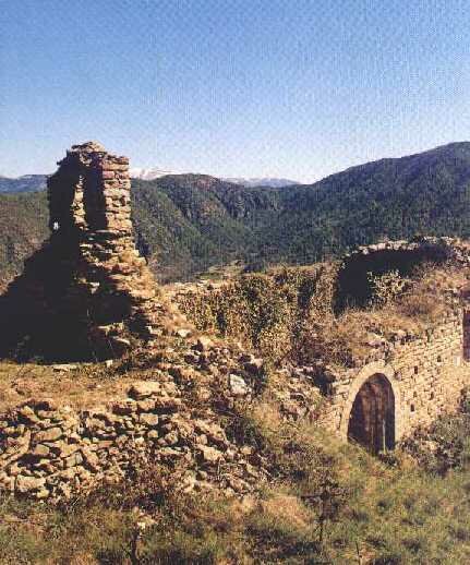
Romanesque. The three románicos vestiges of the municipality are them ruins of the church of Sant Martí de Ansovell, located shortly before arriving at the town, next to the highway; the church of Sant Cristòfol de Vinyoles, with the house also of medieval origin; and the rest of the chapel of Sant Romà de Vima. The two last ones are in particular lands. 

The legend of the Quer. They tell that, once, a traveller asked a neighbor of the Querforadat that taught the famous hole to him, and the one of the Quer responded to him: "To the Quer, forat tothom sél tea"...

Rest of the church of Sant Martí de Ansovell. (Clicad to see the greatest image).
They know of where comes to this town the name to him from Querforadat? Explained Joan Obiols in the pages of its book "Nits de Taverna" (Garsineu Edicions. Tremp, 1995).

 
THE DATA  * CELEBRATIONS *
Extension 42,05 km2 Ansovell 2º Sunday of November 
Population  61 habitantes El Querforadat Penultimate Sunday of August 
City council  APLECS "ROMERÍAS"
* * Mare de Déu del Boscalt to 1er Sunday of September 

 
To return to the principal page

 
Extracted data of the opuscule " Els colors of the Pirineu " published by the Local Consell of l'Alt Urgell